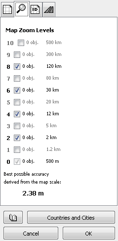
Map Zoom Levels Tab
![]()
These settings apply for the whole map.
Map uploaded into GPS device has several layers (zoom levels). Each zoom level contains different amount of data to speed-up displaying of map and to prevent too many objects being displayed in higher zoom.
Controls on this tab allow user to define number of zoom levels and approximate zoom by which map layers appear on the GPS display.
The number of objects visible in respective zoom level is displayed at the right side of the check box.
In zoom level 0 all objects are visible. The higher is the zoom level, the lower is the number of visible objects. Use controls in above parameter tabs if you want to make some individual object or all objects of the same type more visible or less visible. When you define zoom level of individual object (POI, for example) zoom level 6 means that object will be coded into all available layers from layer 0 up to layer 6, which is visible at zoom 30km or closer.
Upper layers contain less objects coded with lower accuracy for fast and legible rendering of maps in GPS. GPS does not render all layers at the same time - it chooses the one closest to the current zoom. Each layer is coded with approximately 2 times lower accuracy than below layer.
For detailed maps the most important layer is layer 0, with best possible accuracy. This layer, however, requires lot of memory space because it contains all objects and coordinates are coded with best accuracy.
Most of custom maps can use default zoom levels. In some cases it may be useful to redefine one or two levels to optimize appearing layers as you zoom in because GPS uses slightly more complicate logic to choose which layer is displayed at which zoom. For example, layer 6 does not necessarily appear at zoom 30 km. On some maps it can appear one step above or below 30 km zoom.
Best Possible Accuracy informs you about accuracy available for the current map scope (map coordinates range) when uploaded map to the GPS. Internal data structures of GPS use coordinates grid that limits coordinate accuracy to approximately this value.