Move Image
When drawing vector map with use of scanned paper map and tracks acquired with GPS unit, you can often encounter the problem of paper map not matching the tracks, even if it was declared as a 'GPS map'. If the whole image is just shifted, the main menu / Image/ Move function can be used to position the image under the vector tracks properly. In other cases, please click here for more image editing and calibration tools.
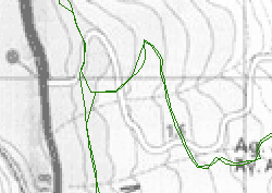
Fig. 1. Image under the vector objects needs to be shifted.
Let's suppose that deviation is constant in this case. Click on main menu / Image/ Move command to start image adjustment. Place pair of points to mark the current and desired position of any spot on the raster image.
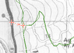
Fig. 2. Current and desired position of spot on raster image. The shift direction is marked by an arrow.
Click right mouse button to access a pop-up menu. Select Move to shift the raster image.
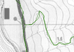
Fig. 3. Image shifted to fit under the vector objects.