Main Window

of Mapwel GPS Mapping Software

Layout of main window controls - screenshot

1
The Tool Bar contains tools for creation, editing and transformation of objects.
2
Work Area. When starting a new map, the work area is blank. User can import scanned image or photo into the background of work area. Default colors of work area and grid lines are specified and can be changed in main menu > Edit > Preferences.
3
Display Mode Tabs. In User mode, all objects (background image and map objects) are displayed in user colors. In Image mode only the background image is displayed. In Vector mode only the map objects are displayed (in user colors). Grey Scale mode simulates the monochrome display of GPS units and Color mode simulates the color display of GPS units. Use the last two modes to see how the map will look in GPS.
4
Button bar. The most used functions from main menu and pop-up menus are accessible through these buttons.
5
Palette of Colors. Click right mouse button on any color to adjust this color. To change color of an existing object, press left mouse button on color and drag and drop it on the object icon in Objects Inspector window or on the selected object in the work area. To set color that will be used for newly created objects click left mouse button on any color. Color that will be used for new objects is outlined in black and white.
6

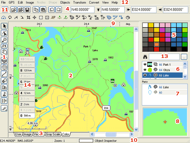
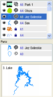
Object Inspector window. All objects created on working area are displayed here in order of creation. It shows order of objects, their type, visibility, name and comment.

When composing complex map with many objects, it is sometimes difficult to isolate desired object in the work area. Use Object Inspector in this case. To change order of objects, select them with right mouse button, drag them to their new position, and release mouse button. To Hide/Show object click the eye icon to the left of each object.

To access menu to duplicate, delete, or change properties, click right mouse button on selected objects in Object Inspector window.

To change color of object in Object Inspector, press left mouse button on any color in Palette and drag it to this object. Then release the button. Another way is to double click the object icon to access the color dialog box, or use the Color command from the pop-up menu.

Color can be also dragged and dropped from object in the list onto the palette.

To select non-contiguous subset of objects, depress the Ctrl key and left click on each object.

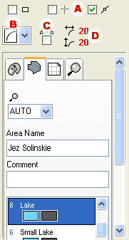
In the editing mode the Object Inspector and Part Inspector windows are replaced with basic parameters of the object.

Object Inspector - list of objects with icons and info  Properties of edited objects displayed instead of Object Inspector

Read more in Object Inspector chapter.

7
Part Inspector window. Openings (holes) of area objects are displayed here as well as parts of grouped objects. This window serves to select holes and parts for further manipulation, because they cannot be selected in work area and in Objects Inspector.
8
Magnifying window. This window displays enlarged area around mouse cursor. It aids precise placement of nodes, allowing user to maintain view of design in the Work Area. To hide this window, use View/Zoom Window; this will enlarge the Parts Inspector window. When cursor moves over Object Inspector, this window displays enlarged object icon and description.
9
Rulers. Press left button on vertical or horizontal ruler and drag mouse to Work Area to create a Guide Line.
10
Status Bar. The mouse cursor coordinates, zoom and tool hint or other information are displayed here.
11
Button for sending the map into the Garmin GPS unit. Same command is available in main menu / File.
12
Main Menu.
13
Find Object control. Type several characters of searched object name or comment into this box. If object with name or comment that begins with these characters exists, Object Inspector scrolls the list to make found object visible and selects it.
14
Zoom Levels Preview. Use this control to preview how map layers will be displayed in GPS at various zoom levels.
A
Snap Nodes options. Use these check boxes to define snapping of nodes to work area edges, guide lines or other nodes. Snapping helps precise placement of nodes. Same options can be found in main menu / Nodes.
B
Curve or straight line vector edge Edge Mode combo box - choose line or curve edge as default when creating new objects.
C
Creating middle point on curve element prior to the end point Middle Point First check box - if checked, new curve element is created so that on first click, line is created. On a second click line turns to a curve using the previous point (end of line) as middle point of curve. If it is not checked, the curve is created on a first click, but the middle point must be dragged to proper position.
D
Curvature of the rectangle with rounded corners.
E
Basic parameters of the newly created object. More parameters can be accessed with use of Objects / Properties menu after finishing the object.